Travel Guide Mont Meru
Find an accommodation
Advertising
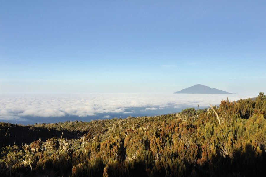
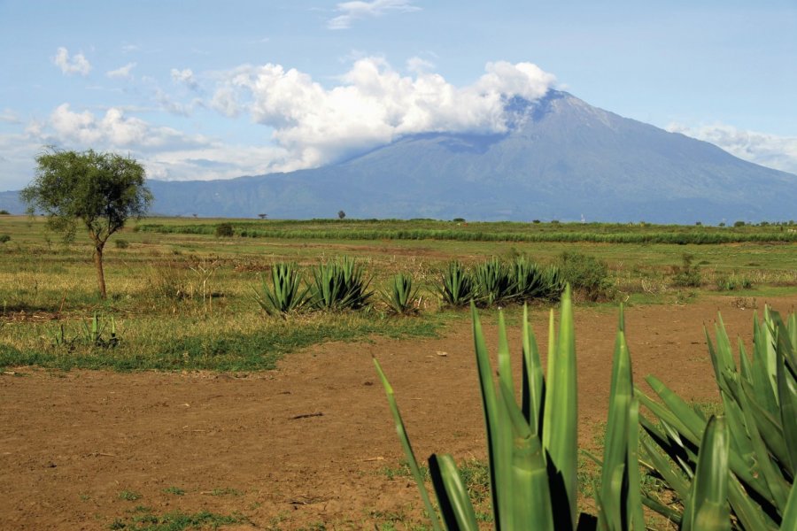
Mount Meru is located within the Arusha National Park, and its ascent in itself is an expedition to be planned in advance. It's a superb volcano, 4,566 m high and some 20 km in circumference at its base, half of which is open to the east through a huge crater resulting from a gigantic explosion. From the crater to the semicircular ridge of the summit, the explosion left walls more than 2,000 m high. In the middle stands an impressive, almost perfectly circular lava cone, dating from the last eruptions at the end of the 19th century. The volcano is far from dormant, as smoke was observed here in the 1940s and hot springs still gush forth. It is Africa's fifth highest peak, after Kilimanjaro (5,895 m), Mount Kenya (5,199 m), Mawenzi (5,149 m) and Rwenzori (5,109 m). The volcano, once known as the "Socialist Peak", is named after the Bantu ethnic group that inhabits the plain at its foot on the northeast side: the Wamerus.The climb. Mount Meru offers a beautiful trekking route, which can generally be completed in 3 days, if not 4. For formalities, a supplement is payable per person at the entrance to Arusha National Park. The trek represents no technical difficulty and absolutely no objective danger, as long as you follow the normal route on foot, and don't lose your guide. Sportsmen and women trained in high-altitude effort can climb this very interesting peak in 2 days, by combining stages 1 and 2. The ascent must be booked in advance with the park, as it is compulsory to pay the applicable taxes and to leave with an armed guide, given the presence of buffalo, elephants and leopards on the slopes. It's also advisable to hire a cook to carry food and drinking water for the duration of the trek. To ensure the success of your ascent, it's best to go through an agency that will take care of all the organization, transport, supplies... Beware: unlike the guarded refuges of European mountains, those here don't offer meals or cooking equipment.Unless you have at least 3 or 4 days to rest in the meantime, don't consider this climb as a preparation for Kilimanjaro, because it's quite tiring, and because the acclimatization mechanisms only come into play significantly after 4 to 8 days at altitude. At the summit, atmospheric pressure and oxygen levels are only 56% of those at sea level. Drinking around 4 liters a day during the ascent can, however, greatly aid organ perfusion and oxygenation, and reduce the risk of altitude sickness.Day 1: Momela - Miriakamba Hut. After formalities and contact with your guide at Momela Gate (1,500 m altitude), we begin our crossing of the Ngare Nanyuki River. On a beautiful, gently sloping forest track, we cross several fords, pass under the fig tree arch (an impressive strangler fig tree, forming an arch under which off-road vehicles can pass), before reaching the Maio waterfalls in an hour and a half. Another hour and a half and you reach Kitoto Camp, from where, sky permitting, the view of the Momela lakes, Arusha National Park and Kilimanjaro is splendid. It then takes another hour to reach Miriakamba Hut, at 2,510 m, via the Meru crater, a large plateau open to the east, covered with thickets and clearings, and inhabited, as on the first slopes, by numerous animals (giraffes, warthogs). We recommend that you ask your guide to pass by the Njeku viewpoint, from where you can contemplate the crater, the beautiful waterfalls and the lava cone. If you don't go there, you can return between 4 and 6.30 a.m., after settling in and resting at Miriakamba Hut.Day 2. Miriakamba Hut - Saddle Hut. We set off in the early morning for a 3-hour hike up 1,000 m of ascent, saving your strength. The trail is fairly steep and follows a ridge. Temperatures remain pleasant and the lush, almost tropical vegetation gradually gives way to heather. Dinner and overnight stay at the Saddle Hut, situated at 3,750 m, just below the pass joining Mount Meru to Petit Meru. Don't count on water: very often, the spring has dried up. So take all the water you need, or have someone take it for you, from Miriakamba. In the afternoon, if your legs still carry you, you can climb Petit Meru (3,820 m) in an hour, and contemplate the orange, then rosy blaze of Kilimanjaro's snows at dusk.Day 3. Rhino Point and summit. Rise early in the night (around 1:30 or 2 a.m.), and walk slowly along a path, soon of rock and ash, to Rhino Point, marked by a cairn(diwe in Swahili), where we arrive after an hour. It can easily be -10°C. Depending on your departure time (if you're up at 4 a.m., so you don't have to climb all the time in the dark), you can watch the magical sunrise over Kilimanjaro and the surrounding region. The heather becomes rarer, and you take to the narrow, airy ridge that forms the rim of the crater and overlooks the lava cone, where the view is spectacular (if it's still dark, you can enjoy it on the way down). During the rainy season, the ridge may be covered with a little snow or ice, which can be climbed without difficulty. After a 3-hour hike and the crossing of numerous jumps, each of which always seems to be the last, the summit is finally reached. At 4,566 m, you can see all the main volcanoes in the north of the country, located on the Great East African Rift, including the still active Ol Doinyo Lengai, as well as the city of Arusha if the sky isn't too overcast, which isn't usually the case in the early morning.Descent. The same route takes 4 hours to Miriakamba, where you take the path that follows the ridges formed by long lava flows and descends directly, in 2 hours, to Momela Gate, through tall grass and thickets inhabited by giraffes, zebras, elephants and buffalo. The latter have an unfortunate tendency to charge into bushes, probably to defend themselves, so it's essential to follow the park's armed guide closely. Rest assured, however, accidents are extremely rare. This last stage can be divided into two days, with a stopover at Saddle Hut or Miriakamba Hut on the way back. Before crossing the meadows that join the lower slopes to the park entrance, you can pass by the large and beautiful Momela waterfall (Momela or Tulusia Falls). Finally, at Momela Gate, your guide hands you the document certifying that you have conquered the summit of Mount Meru.
Suggested addresses Mont Meru
Weather at the moment
Advertising
Organize your trip with our partners Mont Meru
Transportation
Book your plane tickets
Car Rental
Boat rental
Accommodation & stays
Find a hotel
Holiday rental
Find your campsite
Tailor-made trip
Immersion travel
Services / On site
Activities & visits
Find a doctor
Mont Meru travel inspiration


Find unique Stay Offers with our Partners


Other destinations nearby Mont Meru
5 km away
25 km away