Corniche
Even before the discovery of oil, the Corniche was a natural sandy beach battered by storms, where fishermen unloaded the fruits of their catch from dhows. Since then, the Corniche has undergone several major modifications. On the instructions of the sovereign, and with the help first of the Japanese urban planner Takahashi and then of the Egyptian Makhlouf, the city's urban planning began with an orthogonal grid plan featuring wide avenues and green spaces, with no skyscrapers. Starting from the Corniche, it developed in several phases, ending with the area around the bridges at the end of the 20th century. It was not until the death of the father of the nation at the end of 2004 that the capital's government authorized the construction of skyscrapers, which have since been erected around the perimeter of the island. In 1988, a 4.2 km² dike called Lulu Island was built, and in 1998, 800,000 m² were reclaimed from the sea to enlarge it. In 2008, a 2 km-long beach was created along the seafront to provide a bathing area for all residents, and in 2018, the seafront on the western corniche was redeveloped to accommodate new infrastructure further away from the road. Over the years, it has remained a gathering place for the national holiday, but also a place of communion for all the island's inhabitants, who enjoy long strolls or bike rides in fine weather. The most beautiful districts are to the west: Ras Al Akhdar, Breakwater, Khubeirah, to the east Khalidiya, Mushrif and above all Al Bateen, home of the princes. A wealth of toponymy with several points of interest will hold your attention: the Emirates Palace opposite the Etihad Towers (luxury hotel and mall ) and close to the gigantic presidential palace and the monument to Zayed, the malls of Marina and Khalidiya, the landscaped public beach. This western part of the city, bathed by the lagoon waters of the Khor Al Bateen and the more marine waters of the Breakwater, remains almost entirely what it was when the city was founded: a residential area planted with a few rare towers and criss-crossed by majestic axes. These lead to palaces, villas, flower-filled parks and the sea.
The Centre
The Centre is no longer at the centre, such is the cruel fate of the former New World districts. If the city now runs towards the airport and Yas Island, across the bridges, that is no reason to forget what was the beating heart of the Abu Dhabi of the oil boom, near the natural harbour lung. Mina, Markaziyah, Madinat Zayed, Tourist Club, Dhafrah, Wahda, Nahyan, Muroor, East Khalidiyah: streets, gardens and buildings known to all Emiratis. At that time, there was no paved Corniche; one stopped the car on the sand of the sea front. Boosted by the exponential development, architects built an American-style "downtown", planted with buildings and then towers. They even built the first giant shopping mall, the Abu Dhabi Mall. Ten thousand cars later, everything came to a standstill as the two-lane roads of the 1980s were not enough. Gradually, the retailers gave up for more open areas with parking, and the mall ceased to be a mall. But a major facelift is underway and it is now an Abu Dhabi of businessmen (banks, import-export), but also and above all that of shopkeepers, kabob shops and families from the Indian subcontinent. At night as well as during the day, you can move around in complete safety, enjoying the taste of this joyful disorder (very relative), all the more so since you know how rare it is in the kingdom of flowery avenues and giant malls . In this part of Abu Dubai, not far from the Foster+Partners towers, you will discover the historic Qasr el Hosn fort and the cultural foundation, both recently renovated, as well as the very respectful handicraft centre.
Around the bridges
While there are many bridges in the capital, only the three structures in the district link Abu Dhabi Island to the mainland, spanning the 250 m-wide Khor al-Maqta inlet: declined from north to south, here are the dune-shaped Zayed Bridge, by the prestigious Iraqi-British architect Zaha Hadid, the concreted Mussafah Bridge and the historic metal Maqta Bridge: "The Maqta causeway, built in 1952, was the only road linking the city to the coast until 1961," explains Mohamed al-Fahim(De la pauvreté à la richesse, ed. Gulf Book Centre). "Made of stone and mud, it was raised two feet above the water level, allowing cars and camels to use it easily to cross the canal." Taken in the broadest sense in this guide, the district encompasses the hotels, restaurants and boutiques of the elegant waterfront Qaryat al-Beri, the majestic Sheikh Zayed Mosque just across the street, but also 5 km down the island, the Adnec exhibition center and the sports city built in the late 1970s Zayed Sports City. This peaceful, airy capital, surrounded by lagoons, was voted the safest city in the world in 2021.
Reem Island and Maryah Island
These two islands are still under development and are part of the Abu Dhabi 2030 urban plan designed by the urban planning council created in 2007 to support the diversification of the emirate's economy away from hydrocarbons. Located between Abu Dhabi Island and Saadiyat, these sandy archipelagos, reshaped with mechanical shovels, rise only a few metres above the sea and are an extension of the centre of Abu Dhabi, which is a few hundred metres away, and are linked by four bridges. Maryah Island is home to the financial and commercial centre of the capital with free trade zones, a prestigious hospital, shopping malls, luxury hotels and a residential area connected to each other by a promenade of more than 5 km, but also a branch of the private management school of Fontainebleau: INSEAD. Eventually, 30,000 residents and nearly 75,000 employees are expected. To the northeast, near the mangroves and a short distance away, there is Reem Island, 650 hectares near the mangroves that will house the Sorbonne, schools and huge residential towers designed by renowned architects, whose master plan should leave 50% of the island for green spaces, promenades and playgrounds. When the final phase is completed, 200,000 residents are expected to live on the island. These archipelagos are open to expatriates who can acquire movable property, which they were denied on the historic Abu Dhabi island.
Saadiyat Island
12 km from the Emirates Palace, 5 km from the first streets of the city center on the other side of the Sheikh Zayed Bridge, above a vast lagoon area, Saadiyat Island offers a close-up view of the two islands of Maryah and Al Reem. To cover the 30-odd kilometers separating it from the international airport, it's best to take the multi-lane Sheikh Khalifa bin Zayed E12 highway towards Yas, rather than face the hassle of the city center. Until 2006, Saadiyat Island, literally "Island of Happiness", was little more than a desert beach where residents would venture out on weekends for picnics. Since then, it has become one of the focal points of the "new" Abu Dhabi, where culture reigns supreme and whose development over its 27 km² will take some fifteen years. There are 4 main hubs: a cultural district where the Louvre Abu Dhabi awaits the arrival of two other museums: the Zayed Museum by architects Fosters+Partners, dedicated to the history and heritage of the Emirates, and the Guggenheim by architect Franck Gerry. Announced following the peace agreements signed between Israel and the United Arab Emirates, among others, the House of Abraham is an architectural project that will symbolize inter-religious dialogue with the construction of a church, a mosque and a synagogue, and is due to open at the end of 2022. As for the tourist district, for several years now it has been home to magnificent hotels along the white sandy beach, as well as an 18-hole golf course. Finally, the luxurious residential district is already very popular and will eventually be home to some 160,000 residents. The area is also home to several educational institutions, including New York University, and schools such as the French secular school Théodore Monod.
Yas Island
Inhabited for millennia, the master plan for the 2,500-hectare island was presented in 2006 and developed by Aldar, Abu Dhabi's leading investor, with the guiding idea of devoting this archipelago to leisure activities, with a residential area eventually accommodating 55,000 inhabitants. Located 10 minutes from the airport, on the road between Abu Dhabi and Dubai, 30 minutes from the center and a few kilometers from Saadiyat, the island was opened for the Formula 1 Grand Prix in November 2009. Since then, 3 theme parks and dozens of leisure and entertainment proposals have opened to the many tourists and residents with the help of renowned architects.
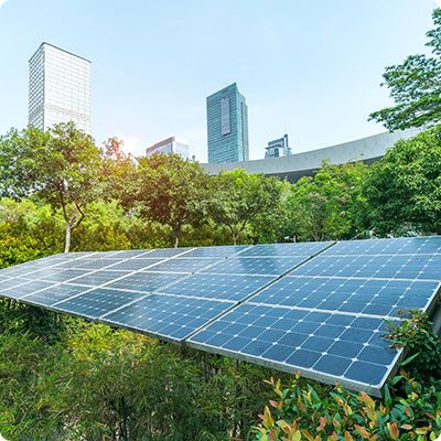
Khalifa and Masdar City
This suburb of Abu Dhabi is located between the airport, Yas Island and the entrance to Abu Dhabi Island on the road linking the capital to Dubai. It comprises Khalifa City A, with around 80,000 residents, and Khalifa B, currently under construction and expected to house around 70,000. No skyscrapers are visible, and this immense complex comprises villas and small buildings where Emirati and expatriate families live together around 8 schools. This is also the site of the eco-responsible Masdar City project, which aims to be a model of economic, social and environmental sustainability.