A temperate climate
The climate of Yvelines, like that of the Ile-de-France region, is temperate, with hot and cold seasons. It is subject to two influences: oceanic to the west, and continental to the east, as well as an attenuation caused by the warming of the Paris conurbation. The average annual temperature varies between 5°C and 19°C, with occasional periods of drought or heatwave in recent years. The climate is not very humid, with average annual precipitation of 600 mm. Thanks to prevailing westerly winds, Yvelines is relatively sheltered from pollution peaks from the Paris conurbation, offering a breath of clean air. In summer, thunderstorms are common, cooling the air. The slopes of the Seine valley are known for their local variations, known as microclimates, which influence the banks of the river and the surrounding area.
Characteristic landscapes..
as "Yvelines" means "abundant in water" from the Celtic ioline, the department's very name reflects a geographical reality. The current appearance of the region and the département is due to erosion caused by rivers. The Ile-de-France region, and the Yvelines in particular, is characterized by a series of medium-altitude plateaus (around 150 m), into which the tributaries have dug their beds to join the Seine. Rising to 231 m, the hill of Elancourt is the highest point, as is the Paris region, with a breathtaking view of the Eiffel Tower. Finally, several natural regions are also representative of the Yvelines landscape: the French Vexin to the north, the Mantois, the Seine valley, the plains of Versailles and Monfort, the Drouais to the west, the Beauce at the southern tip, the Hurepoix to the southeast, and the Rambouillet forest massif.
...crossed by rivers.
Although man, his hands and his tools are almost omnipresent (roads, housing and industry), the Yvelines landscape also knows how to take root and remain endearing, thanks in particular to the water that encourages the growth of forests. In addition to the Seine, waterways cover almost 700 km of the département. The river drains part of the Paris Basin, but also crosses the entire north of the region upstream, meandering in long stretches, and its banks - thanks to a host of tributaries and sub-tributaries born on Yvelines soil (Mauldre, Yvette, Orge, Renarde, Drouette, Vesgre, Vaucouleurs) - still offer a number of natural environments, including the chalk cliffs bordering the west and other rural vistas. The department also boasts a number of ponds (some of them man-made), which are gradually being transformed from wild ponds into sophisticated water features. A new awareness of the importance of wetlands is now helping to safeguard or restore certain marshes that are home to a wide variety of flora and fauna.
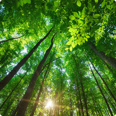
The forest at the heart of the department
Woodland covers over 30% of the Yvelines region. The state-owned forests of Saint-Germain-en-Laye, Marly-le-Roi, Rambouillet and Dourdan, as well as privately-owned forests, are undoubtedly the department's greatest asset. With forest formations covering 65,000 ha, the département is undeniably the most wooded in the whole of Ile-de-France, and is often referred to as the region's "green lung". Because they are home to an often remarkable flora and fauna, because they are also restful, airy green spaces in urban panoramas that are sometimes overly structured, and because they offer a world of relaxation for the people of Yvelines, these wooded areas have three main focuses of interest: ecological, landscape and recreational.
The islands of the Seine
There's a mosaic of islands to discover along the banks of the river, and here's a selection of them.
Île de la Chaussée - Bougival
The island offers a beautiful view of Bougival and the hills of Louveciennes. It features a park, sports complex, picnic tables and children's playground. Sheltered by trees and on the banks of the Seine, it's a peaceful place to stroll, disturbed only by passing barges on one side and the sound of golf clubs on the other.
Île de Migneaux - Poissy
A mecca for Impressionist painters, it was on this islet embedded in the town of Poissy that Pissarro and Monet came to paint the banks of the Seine. It has to be said that the particular luminosity of this place is quite seductive. With a touch of nostalgia and imagination, you'll have no trouble immersing yourself in the jovial days of the guinguettes of yesteryear.
Île Nancy - Andrésy
Île Nancy, or Andrésy Island, is a 35-hectare natural area almost entirely wooded. A ferry provides free access. For the curious, there's a fish pass to allow migrating fish to swim upstream.
Île l'Aumône - Mantes-la-Jolie
Here, Camargue horses and Scottish Highland cows look after this bird sanctuary. It's a peaceful place where it's good to wander between the different areas: meadows, wetlands (pond, observatory lake and educational pool), fallow land, country hedges and forests.
Île des Impressionnistes - Chatou
This island owes its fame to the painters who came here in the 19th century to set up their easels and paint landscapes. An ideal place for a stroll, the island is criss-crossed by cycle paths and is also the starting point for cultural tours.