TONGARIRO ALPINE CROSSING
Go there and contact

Often described as New Zealand's finest one-day trek, its reputation is far from usurped. This 17 km itinerary traverses some of the country's most beautiful and impressive scenery, along a perfectly signposted trail with no difficulties other than its length and climbs. Anyone can do it, provided they're in good physical condition and the weather's cooperating. The adjective "alpine" does, however, underline the nature of the terrain and the differences in altitude, and you shouldn't venture out without preparation, food and equipment (good shoes, warm clothing, windbreaker and/or raincoat).
It's essential to check the weather forecast with the Department Of Conservation before setting off, as the region's weather can be unstable. What's more, you're climbing high, and blue skies at Whakapapa village don't mean it's going to be warm and sunny at the top - far from it! Even in midsummer, it's sometimes too cold on the summits to linger too long, so you quickly eat your sandwich and head back!
Nonetheless, this is an absolute must-see during your stay, as the change of scenery provided by the lunar volcanic landscapes is breathtaking. It's not for nothing that the region served as the setting for Mordor in The Lord of the Rings...
There are many other worthwhile hikes in the park, and if you want to be sure not to miss this one, it's a good idea to plan several days in the area. Unfavorable weather can make the experience far less impressive. Visibility is sometimes so poor that you can barely see the markers, let alone the scenery...the physical challenge is always interesting, but you still lose an essential dimension of the adventure.
At other times, the wind may be too strong, and even if the sky is blue, the shuttles may decide not to make the trip so as not to put hikers in conditions that could prove dangerous.
So it's best to plan ahead for a few days to be sure of a favorable weather window, and explore the rest of the park in the meantime. The wait may be frustrating, but the reward will be all the greater!
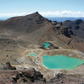
The hike starts at Mangatepopo Road Car Park, in the west, and ends at Ketetahi Road, in the north, for a total of 6 to 9 hours' walking, depending on your pace and the detours you allow yourself. The route takes in superb lakes (Emerald Lakes and Blue Lake) and the park's three mountains, Mount Tongariro, Mount Ngauruhoe and Mount Ruapehu.
Mount Tongariro is the smallest of the three peaks, at 1,968 meters above sea level. It is a volcano with numerous craters, some of which are still active. It is also home to mud pools and hot springs on its northern slopes. It last erupted in 2012, and some hiking trails had to be closed due to the propulsion of rocks and ash over part of the park. If you want to climb a mountain during the trek, this is the one to choose, as the detour takes little more than 2 hours and is the best marked.
Mount Ngauruhoe. Everyone talks about it by the name that made it famous: Mount Doom. Indeed, it was its perfect cone, culminating at 2,287 meters, that was chosen as the "Mountain of Destiny" in the famous saga based on the novels by J.R.R. Tolkien. Unlike the other two volcanoes, this one has only one crater. Still active, it is said to have erupted more than seventy times since the arrival of Europeans in the region. Because of its reputation, many hikers rush to its slopes unprepared. We strongly advise against it. There are no fixed paths, the terrain is essentially made up of highly impassable ash and its 45° incline makes it an extremely complicated climb. What's more, the numerousfalling rocks caused by other walkers regularly result in injuries. Only the most experienced climbers will be able to attempt this detour in good weather, following the signs that indicate the safest route.
Mount Ruapehu. At 2,797 meters above sea level, this is the roof of the North Island. This volcano is still very active, so much so that its last eruptions in September 1995 and June 1996 sent ash as far as the east coast. The volcano has twice disrupted ski resort operations. Of the region's four resorts, three cling to its flanks: Whakapapa on the western slope, Turoa to the south and Tukino to the east. It dominates the crossing 's backdrop, but never comes close.
Transport: A shuttle bus is virtually unavoidable on this trek. As the itinerary is not a loop, some people sometimes plan to go in two groups with two vehicles, which is mathematically forbidden as you are only allowed to leave your car in the parking lot for 4 hours, and the walk takes at least 6. In addition, if you take the trail from Ketetahi Road, you'll be walking against the flow of all the other hikers, which, given how busy the trail is, can be very unpleasant.
Unless you have a friend willing to take a cab at the beginning and end of the day, you'll need to book a shuttle service.
Most accommodations organize their own shuttles to and from all tourist destinations in the region, so it's best to check with them directly. There are also a number of private shuttle companies. Information is available at the Visitor Centre or on the Internet.
Seasons
As you can see, even in the height of summer, weather conditions can give you a wintry feeling, especially at the summit! But if you're well equipped and prepared, there's no problem. In winter, on the other hand, it's advisable to venture out on the trail ONLY if you have mountaineering experience (and the right equipment, of course).
If you don't have mountaineering experience but really want to see the crossing under the snow (and we understand!), some companies offer guided expeditions with experienced guides. Clearly an unforgettable experience if you get the chance.
Symbolism and legend
The area you pass through on this hike is tapu - sacred - to the Maoris, so please show respect. In their own words: "We welcome you into our world, a world of respect and reciprocity, of protection of and devotion to the land, of incredible landscapes and epic legends, of profound reverence and spirituality. May the guardians of our mountains protect you, may the memories of your experience here remain forever in the warmth of your heart".
The legend evoked here is that of the four mountain warriors - Tongariro, Taranaki, Tauhara and Pūtauaki - fought for the love of Pihanga, a mountain-woman with whom they were all enamored. Tongariro won the battle, and the other mountains went into exile after their defeat. Tauhara left for the other side of Lake Taupō, from where it overlooks the city some 60 km to the north. Pūtauaki headed east, stopping at Kawerau. Taranaki, who was Tongariro's fiercest competitor, set off westwards, tracing a deep furrow in his path which became the bed of the Whanganui River, fed by Tongariro who, seeing the wound Taranaki had inflicted on the earth in his flight, created a spring to soothe it and fill it with water.
Today, Taranaki still mourns his lost love. It's said that when he's covered in clouds and lost in fog, he mourns the loss of his beloved. Conversely, when he's bathed in sunlight, he shows Tongariro his power and glory. Tongariro, for his part, sometimes spits smoke and ashes to remind his rival that it would be unwise of him to try to return.
The Maoris have long considered it unwise to settle between the two mountains, in case they decide to resume their fight for Pihanga.
Did you know? This review was written by our professional authors.
Further information
Opening time and information on TONGARIRO ALPINE CROSSING
20 km hike, 7 to 9 hours walking. Preferable to go by shuttle bus.
Book the Best Activities with Get Your Guide
Members' reviews on TONGARIRO ALPINE CROSSING
The ratings and reviews below reflect the subjective opinions of members and not the opinion of The Little Witty.
Trek long et difficile sur la journée
Il faut compter entre 8 et 9 heures de marche. À faire par beau temps de préférence pour les vues splendides.
Déposer son véhicule au car parc au point d'arrivée et prendre un Shuttle pour se rendre au point de départ. Distance du trek: 19,4 kms.