7 JOURS MACHAME KILIMANJARO TREK EN GROUPE ( 24 JUNE AU 02 JULY 2025)
Join our international group departures to Tanzania and experience the adventure of a lifetime! Whether you want to conquer the peaks of Kilimanjaro or Mount Meru, or immerse yourself in the breathtaking wildlife of our safaris, we've got you covered.
Why choose us?
Smaller groups: Enjoy a personalized experience with a favorable guide/client ratio, ensuring you receive the attention and support you need on every trek.
Guaranteed departures: Most of our group tours are guaranteed to depart, even if you're the only one to have booked. Your adventure is always on!
Flexible options: Combine several experiences - climbing, trekking and safari - for extra savings, or choose your adventure as a stand-alone package. The choice is yours!
Highlights of the trip
During your stay you can enjoy the following highlights: Culture / Heritage, Faune and flora, Off the beaten track, Nature travel, Travelling alone and travelling in a group.
Best months to go
The best time(s) to go is/are : Janvier, Juin, Juillet, Août, Septembre, Octobre, Novembre, Décembre.
How to get there?
You can get there by Plane.
SHAH TOURS
From 2210€ à 2250€ / person
Travel suitable for :
Detail of the stay : 7 JOURS MACHAME KILIMANJARO TREK EN GROUPE ( 24 JUNE AU 02 JULY 2025) - 7 days
Machame gate to Machame camp

© Shah Tours
Steps: Moshi
Vous serez transféré par la route de la ville de Moshi (09h00) à la porte de Machame. Après l'enregistrement, vous commencerez votre trekking à travers la zone de forêt tropicale avec votre guide. La forêt est épaisse et diversifiée avec de la flore et de la faune, et il est possible qu'il pleuve cet après-midi, ce qui est courant dans cette zone, rendant le sentier légèrement glissant. Une randonnée régulière mais relativement raide vous mènera à la lisière de la forêt et de la zone de bruyère.
Distance approximative en voiture : 1-1,5 heures
Durée approximative de la randonnée : 5-7 heures
Distance approximative du trekking : 9km / 5.5mi
Altitude de départ : 1790m ou 5870ft
Altitude finale : 3010m ou 9875ft
Altitude la plus élevée atteinte : 3010m ou 9875ft
Gain / perte d'altitude : +1220m ou +4005ft
Repas inclus : Petit-déjeuner, déjeuner pique-nique ou déjeuner, dîner
Machame camp to Shira Two camp

© Shah Tours
Steps: Moshi
Today's hike is a little shorter, and begins with a trek through heather and moorland to a steep ridge that leads to the semi-circular cliff known as Picnic Rock. From here, you'll have an excellent view (on a clear day) of Kibo Peak, the highest cone on the mountain, where your goal, Uhuru Peak, lies. You should also be able to see the jagged peaks of the Shira plateau to the west. Shira is Kilimanjaro's third highest peak, shaped by lava flows, erosion and volcanic activity. Tanzania's second highest mountain (Mt Meru 4563m or 14970ft) can be seen in the distance. The rest of the day is spent on a much gentler, flatter track to your camp, where the views are just as spectacular.
Approximate distance by car: None
Approximate trekking time: 5-7 hours
Approximate trekking distance: 7km / 4.5mi
Starting altitude: 3010m or 9875ft
Final altitude: 3845m or 12615ft
Highest altitude reached: 3845m or 12615ft
Altitude gain / loss: +835m or +2740ft
Meals included: Breakfast, picnic lunch or lunch, dinner
Shira Two camp to Barranco Camp

© SHAH TOURS
Steps: Moshi
Today's hike takes you to the Kibo cone, climbing steadily and crossing the edges of the alpine desert to your first high altitude at the lava tower (4630m or 15190ft). This day will help you acclimatize and be a good indicator of your body's ability to cope with higher altitude. From the lava tower, you begin a steep, counter-clockwise descent around Kibo and into the Barranco valley, passing the large flowering mountain cacti (Kilimanjaro Senecios), unique to Kilimanjaro. The day ends at about the same altitude as the start, on the edge of heather and moorland.
Approximate distance by car: None
Approximate trekking time: 6-8 hours
Approximate trekking distance: 10km / 6mi
Starting altitude: 3845 or 12615ft
Final altitude: 3960m or 12990ft
Highest altitude reached: 4630m or 15190ft
Altitude gain / loss: +785m or +2575ft / -670m or -2200ft
Meals included: Breakfast, picnic lunch or lunch, dinner
Barranco camp to Karanga camp

© SHAH TOURS
Steps: Moshi
Today's hike takes you directly to the Kibo cone, climbing steadily through alpine desert. The landscape changes dramatically as you leave behind the heather and moorland area and move onto the arid saddle (the hollow between the Kibo and Mawenzi peaks). You reach the hut in time to rest up for your summit attempt this evening.
Approximate distance by car: Approximate trekking time: 5-7 hours
Approximate trekking distance: 12km / 7.5mi Starting altitude: 3700m or 12140ft
Final altitude: 4703m or 15430ft Highest altitude reached: 4703m or 15430ft
Altitude gain / loss: +1003m or +3290ft Meals included: Breakfast, picnic lunch or lunch, dinner
Karanga camp to Barafu camp

© SHAH TOURS
Steps: Moshi
Today, you climb almost casually through the empty alpine desert landscape, keeping a slow pace even though the path is not extremely steep. The Kibo cone begins to close in and you can finally see Mawenzi Peak (Kilimanjaro's second highest peak) to the east. The short distance means you have plenty of time at summit camp to rest and prepare for tonight's summit attempt.
Approximate distance by car: None
Approximate trekking time: 3-4 hours
Approximate trekking distance: 4km / 2.5mi
Starting altitude: 4040m or 13255ft
Final altitude: 4640m or 15225ft
Highest altitude reached: 4640m or 15225ft
Altitude gain / loss: +600m or +1970ft
Meals included: Breakfast, picnic lunch or lunch, dinner
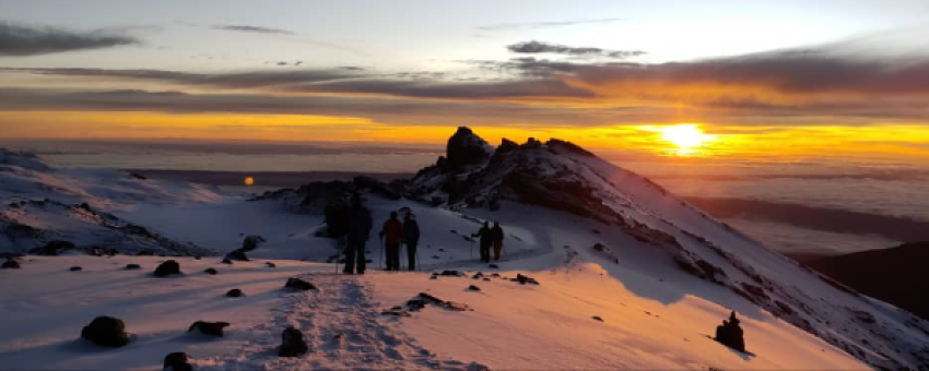
Barafu Camp to Stella point to Uhuru peak to Mweka camp

© SHAH TOURS
Steps: Moshi
Tôt le matin (vers 00h00), vous commencez votre ascension finale vers le sommet du pic Uhuru à travers la zone arctique. Le trekking est une randonnée raide sur des éboulis volcaniques dans la nuit noire et froide et se déroule à un rythme lent en zigzag jusqu'au point Stella (5685m ou 18650ft) qui est votre première étape sur le bord du cratère du Kibo. De là, une courte (mais difficile) randonnée vous mènera au pic Uhuru (5895m ou 19341ft), le point culminant de l'Afrique. Vous ne passerez généralement pas beaucoup de temps au sommet en raison de l'altitude extrême et redescendrez au camp de base pour votre petit-déjeuner / brunch. Après avoir rangé vos affaires, vous continuerez la descente à travers le désert alpin, la bruyère et la lande, pour finalement vous arrêter au camp de Mweka dans la zone de la forêt tropicale pour un repos bien mérité.
Distance approximative en voiture : Aucune
Durée approximative du trekking : 14-18 heures
Distance approximative du trekking : 19km / 12mi
Altitude de départ : 4640m ou 15225ft
Altitude finale : 3080m ou 10105ft
Altitude la plus élevée atteinte : 5895m ou 19341ft
Gain / perte d'altitude : +1255m ou +4116ft / -2815m ou -9236ft
Repas inclus : Petit-déjeuner, déjeuner pique-nique ou déjeuner, dîner
Mweka camp to Mweka gate

© SHAH TOURS
Your last day on Kilimanjaro is a descent through the southern rainforest to Mweka gate, where our vehicle will be waiting to take you back to the town of Moshi. The team will usually leave you at Mweka gate, and this is an ideal opportunity to say goodbye to your team, who usually head straight home from Mweka gate.
Approximate distance by car: 1 hour
Approximate trekking time: 3-4 hours
Approximate trekking distance: 10km / 6mi
Starting altitude: 3080m or 10105ft
Final altitude: 1630m or 5350ft
Highest altitude reached: 3080m or 10105ft
Altitude gain / loss: -1450 or 4755ft
Meals included : Breakfast