Travel Guide Lukomir
Find an accommodation
Advertising
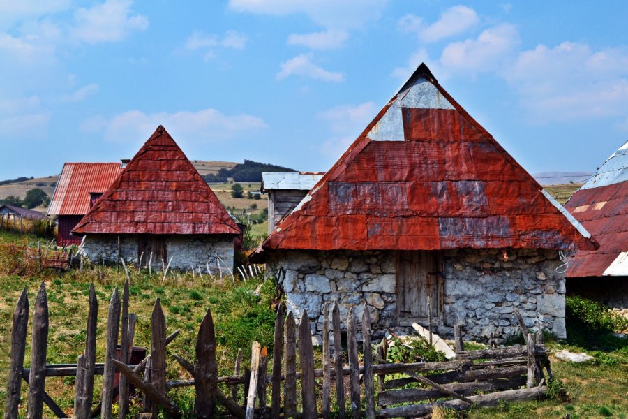
Lukomir/Лукомир (pronounced "loukomir") has about 50 inhabitants, all of whom are Bosnians. The hamlet belongs to the municipality of Konjic, within the Herzegovina-Neretva canton. It is located 22 km southwest of Umoljani(via Kramari), 27 km southwest of the resort town of Bjelašnica(via Kramari) and 28 km east of Konjic.Lukomir is the highest and most isolated place in the country and can only be reached by 4WD. It is located at an altitude of 1,495 meters on the Podvelezje plateau. The scenery here is sumptuous: placed at the foot of Mount Lovnica (1,896 m), the hamlet overlooks the Rakitnica canyon on the edge of an 800 m high cliff. Beaten by the wind and cut off from the world in winter, it was spared by the last war, but has had running water and electricity only since 2003. While the men watch over their flocks of sheep, the women sell socks and traditional handmade clothes. With its postcard decor and its beautiful rectangular stone houses (sometimes topped with corrugated iron...), Lukomir is in the catalog of almost all the tourist agencies of Sarajevo. But this often turns into a "visit to the Indian reserve", in a hurry and without taking into account the traditions of welcome dear to these mountain people. The only exception is the Green Visions agency (see "Moving/bulling" in Sarajevo). It has been running a sustainable development project for 25 years and offers a four-day stay in the homes of local people.
Suggested addresses Lukomir
Weather at the moment
Advertising
Organize your trip with our partners Lukomir
Transportation
Book your plane tickets
Car Rental
Boat rental
Accommodation & stays
Find a hotel
Holiday rental
Find your campsite
Tailor-made trip
Immersion travel
Services / On site
Activities & visits
Find a doctor
Lukomir travel inspiration


Find unique Stay Offers with our Partners


Other destinations nearby Lukomir
5 km away
25 km away